Features
Utility Strike Prevention as Corporate Responsibility: 8 Tools That Protect Excavation Crews

Protecting field workers from injury and preventing neighborhood service interruptions sit at the heart of responsible excavation, and modern detection tools address that social cost directly. Utility strikes remain a persistent and costly problem worldwide, and the problem is not easing. Damage to buried utilities across North America has stayed stubbornly high despite years of industry-wide efforts to reduce it. Underground utility strikes can cause injuries, service interruptions, equipment damage, and costly construction delays. Even when excavation contractors follow utility notification procedures, inaccurate records, incomplete markings, and previously unknown infrastructure can create hazards that remain undetected until digging begins.
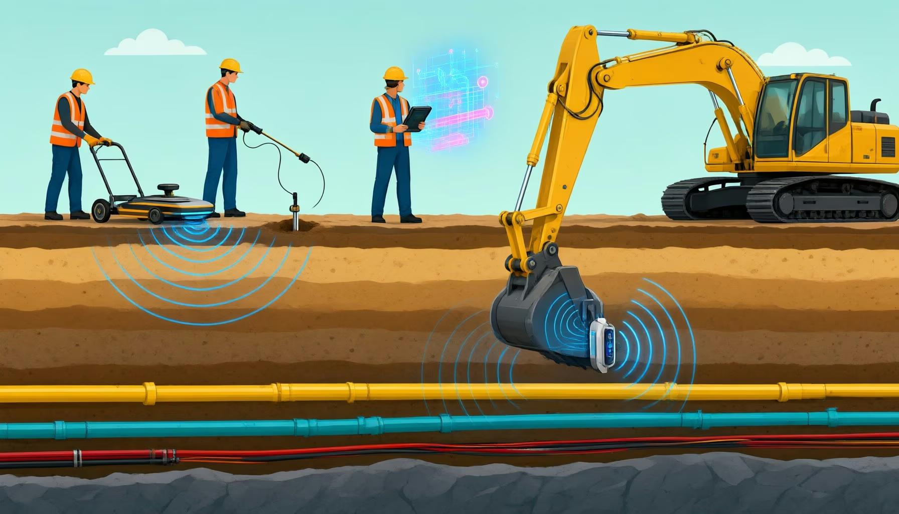
Utility strike prevention tools work in layers. Electromagnetic locators and ground-penetrating radar find buried lines before digging starts, mapping and augmented reality platforms put those records in front of crews, and bucket-mounted radar alerts the operator to utilities while the excavator is already in the ground.
Key Takeaways for Excavation Damage Prevention
No single piece of equipment keeps a bucket away from a live gas service. Damage prevention holds up when records review, locating, verification, and active-dig detection each cover a different failure point, and when the crew can act on what the equipment reports.
- Most prevention equipment operates before digging begins, which leaves a gap between the pre-dig survey and what the operator actually meets in the trench, as Dream Civil’s review of utility strike prevention solutions notes.
- Prevention runs as a chain, described by Technology.org as predicting risk, mapping the subsurface, locating and marking lines, verifying by soft dig, then excavating. Every link except the last happens before the bucket moves.
- Upstream tools reduce the probability of contact. Records can be incomplete, marks drift, and surveys miss lines entirely.
- Real-time systems such as LDR Excavate scan the soil as the operator digs and generate audible alerts when a utility is detected, so digging strategy can change mid-pass.
- A single strike can stop work, injure workers, trigger emergency repairs, and create legal exposure, which is why the documentation trail matters as much as the detection itself.
At a Glance: 8 Damage Prevention Solutions for Excavation Contractors
- RodRadar: Excavator-mounted with Live Dig RadarⓇ technology that detects underground utilities and alerts operators during active excavation.
- Leica Geosystems: Ground-penetrating radar, utility detection equipment, and mapping tools for pre-excavation investigation.
- Radiodetection: Electromagnetic utility locating and ground-penetrating radar technologies for identifying buried infrastructure.
- Subsite Electronics: Utility locating systems, ground-penetrating radar, and field mapping tools for underground construction.
- ProStar: Digital utility mapping and geospatial data management for documenting and locating buried infrastructure.
- GSSI: Ground-penetrating radar systems for subsurface investigation and underground utility detection.
- vGIS: Augmented reality visualization of buried infrastructure using geospatial utility records.
- KorTerra: Utility damage prevention software for locate ticket management, field operations, and compliance documentation.
Why Excavation Damage Prevention Requires Multiple Technologies
Preventing utility strikes requires more than obtaining underground infrastructure records before construction. Excavation crews may encounter abandoned lines, undocumented installations, inaccurate depth information, or utilities that were installed after the most recent survey.
Different technologies address different sources of uncertainty:
- Electromagnetic locating: Identifies and traces conductive underground utilities using electromagnetic signals.
- Ground-penetrating radar: Detects subsurface anomalies that may indicate metallic or nonmetallic infrastructure.
- Real-time excavation detection: Provides operators with information about potential underground obstacles while excavation is underway.
- Digital utility mapping: Organizes utility locations and associated infrastructure information for planning and field reference.
- Augmented reality visualization: Displays available utility records in the context of the physical jobsite.
- Damage prevention workflow management: Coordinates locate requests, field activities, compliance records, and documentation.
These capabilities are complementary. A utility locator may help establish the position of a known line before excavation, while a bucket-mounted ground-penetrating radar system adds another opportunity to identify unexpected infrastructure during digging.
Once excavation begins, most traditional detection tools are no longer active. Crews are effectively operating blind beneath the surface, relying on trust in prior data, which is often missing and unreliable. Anthony Davis, Managing Editor, Highways.Today, in Top 5 Technologies for Preventing Underground Utility Strikes, 2026
Contractors should evaluate technologies according to when they operate, what they can detect, and how their outputs support field decisions.
For excavation employers, pairing field-level crew safety tools with clear compliance documentation is a core part of corporate social responsibility. When teams verify underground hazards and maintain transparent locate records, they protect operators on the jobsite and safeguard surrounding communities from preventable outages.
The 8 Best Damage Prevention Solutions for Excavation Contractors
1. RodRadar: Real-Time Utility Strike Prevention During Excavation
RodRadar develops Live Dig RadarⓇ (LDR), a patented ground-penetrating radar technology designed to identify underground utilities while excavation equipment is actively digging.
Unlike conventional utility detection systems that require separate scanning before excavation, RodRadar integrates radar technology directly into the excavator bucket. This allows the system to collect subsurface information at the point where excavation is taking place.
Its flagship product, LDR Excavate™, combines a radar-equipped digging bucket with onboard processing and an operator interface. As the bucket scans the ground, the system captures and analyzes radar reflections and detects underground utilities in proximity to the bucket. Smart algorithms analyze the radar data immediately and convert those signals into utility locations.
The LDR Visualize interface provides real-time visual and audible alerts, including utility position and depth. Operators can use these alerts to stop, investigate, and adjust excavation activities before proceeding.
RodRadar is designed to detect common buried utility types, including electricity, gas, water, wastewater, and communications infrastructure. Its radar-based approach can identify metallic and nonmetallic utilities, including plastic pipes that conventional electromagnetic locating may not detect directly.
RodRadar also provides LDR Insights, a cloud-based portal for reviewing detection history, managing projects, and documenting excavation activities. The LDR Capture application allows field teams to access scan information and supplement records with jobsite images and annotations.
Key capabilities
- Live Dig Radar technology integrated into excavator buckets
- Real-time underground utility detection during digging
- Automatic visual and audible operator alerts
- Provide utility position and depth information
- Detection of metallic and nonmetallic utilities
- Support for gas, water, power, and communications infrastructure
- Compatibility with different excavator sizes
- LDR Visualize in-cab interface
- LDR Insights cloud-based detection records
- LDR Capture field documentation
- Detection history and project reporting
- Integration capabilities for construction equipment systems
2. Leica Geosystems
Leica Geosystems provides utility detection equipment and mapping technologies that help construction professionals investigate underground infrastructure before excavation.
Its detection portfolio includes electromagnetic cable locators and ground-penetrating radar systems such as the Leica DSX and DS4000. These technologies help field teams identify buried utilities, investigate subsurface conditions, and collect information for excavation planning.
Key capabilities
- Ground-penetrating radar utility detection
- Electromagnetic cable and pipe locating
- Leica DSX utility detection radar
- Leica DS4000 subsurface detection
- Utility location and depth assessment
- Digital field mapping
- Survey and positioning integration
- Subsurface data visualization
3. Radiodetection
Radiodetection develops electromagnetic locating equipment and ground-penetrating radar technologies used to identify underground cables, pipes, and other infrastructure.
Its RD8200 and RD8200SG locating systems help technicians trace conductive utilities and assess their location before excavation. The company’s broader portfolio includes transmitters, accessories, and radar-based solutions for investigating buried infrastructure.
Key capabilities
- Electromagnetic utility locating
- Cable and pipe tracing
- RD8200 locator technology
- Signal transmitters and accessories
- Utility depth estimation
- Ground-penetrating radar options
- GPS-enabled locating records
- Field data collection
- Underground route verification
4. Subsite Electronics
Subsite Electronics provides utility locating and subsurface detection technologies for excavation contractors, underground construction crews, and utility professionals.
Its UtiliGuard 2 product family includes electromagnetic locating systems with different levels of positioning and data collection functionality. The UtiliGuard 2 RTK combines utility locating with high-precision positioning capabilities for mapping detected infrastructure.
Key capabilities
- UtiliGuard 2 utility locating systems
- Electromagnetic cable and pipe detection
- UtiliGuard 2 RTK positioning
- GeoRanger ground-penetrating radar
- Utility depth and position information
- UtiliView field mapping
- GPS-enabled data collection
- GIS data export
- Utility route documentation
5. ProStar
ProStar develops PointMan, a geospatial software platform designed to help organizations capture, manage, and visualize underground utility information.
Instead of detecting utilities directly through radar or electromagnetic equipment, PointMan focuses on making infrastructure records more accurate, accessible, and useful to field teams.
The platform supports utility data collection, location documentation, and integration with geospatial technologies. Contractors can use it to record verified underground infrastructure positions and maintain digital information that supports future excavation planning.
Key capabilities
- PointMan geospatial mapping platform
- Underground utility data management
- Digital utility location records
- GIS integration
- Field data collection
- Utility position documentation
- Infrastructure visualization
- As-built information management
- Data sharing across project teams
6. GSSI
Geophysical Survey Systems, Inc. (GSSI) develops ground-penetrating radar equipment used for subsurface investigation, including underground utility detection.
Its UtilityScan product family helps operators investigate buried objects and potential utility routes without relying exclusively on electromagnetic signals. This is particularly relevant when infrastructure includes nonconductive materials or when utility records are incomplete.
Key capabilities
- UtilityScan ground-penetrating radar
- Subsurface anomaly detection
- Metallic and nonmetallic target investigation
- Underground utility route assessment
- Radar data visualization
- Utility depth estimation
- Field-based subsurface scanning
- Pre-excavation investigation
- Radar data review and interpretation
7. vGIS
vGIS provides augmented reality visualization technology that allows field teams to view underground infrastructure information in the context of their physical surroundings.
The platform connects geospatial utility records with mobile and augmented reality interfaces, helping workers visualize the approximate locations of buried assets before excavation. Its damage prevention workflows also track utility quality levels (A to D) so planners can see how well each record has been verified.
This can improve communication between project managers, utility owners, and field crews, particularly on congested jobsites where multiple infrastructure networks overlap.
Key capabilities
- Augmented reality utility visualization
- Underground infrastructure overlays
- GIS data integration
- Mobile field access
- Utility record visualization
- Infrastructure location context
- Field collaboration
- Geospatial data presentation
- Construction planning support
8. KorTerra
KorTerra provides software for utility damage prevention operations, including locate ticket management, field workflows, and compliance documentation.
Its platform helps utility operators and damage prevention teams manage excavation notifications, assign locating activities, and track responses throughout the ticket lifecycle.
KorTerra also supports field documentation and operational reporting, helping organizations maintain records of locate activities and identify process issues.
Key capabilities
- Utility locate ticket management
- Excavation notification workflows
- Field task assignment
- Locate status tracking
- Damage prevention documentation
- Compliance reporting
- Operational dashboards
- Workflow automation
- Utility damage prevention analytics
How Utility Strike Prevention Tools Compare by Operating Stage
The sharpest difference between these eight solutions is when they are active. Handheld electromagnetic locating and cart-based ground-penetrating radar run before the bucket moves, mapping and augmented reality platforms present records the crew already has, while bucket-mounted ground-penetrating radar operates during active digging as soil is being removed.Approach Solutions in this list When it operates What it reports Electromagnetic locating Radiodetection RD8200, Subsite UtiliGuard 2, Leica cable locators Before excavation Position and estimated depth of conductive utilities traced by signal Ground-penetrating radar GSSI UtilityScan, Leica DSX and DS4000, Subsite GeoRanger Before excavation Subsurface anomalies that may be metallic or nonmetallic, including plastic pipe Digital mapping, AR, and workflow software ProStar PointMan, vGIS, KorTerra Planning, field reference, and documentation Recorded utility positions, locate ticket status, and verification history Real-time excavation detection RodRadar LDR Excavate During active digging Utilities near the bucket with visual and audible alerts, plus position and depth
Deployment effort differs just as much. A handheld locator moves between crews in a truck, while Industry Tap notes that Live Dig Radar requires purchasing or fitting an LDR bucket per machine.
Building a Layered Utility Strike Prevention Workflow
Excavation contractors should treat damage prevention as a continuous process instead of a single task completed before work begins.
A layered workflow creates multiple opportunities to identify hazards and correct inaccurate assumptions about underground conditions.
A practical process includes six stages:
- Review available records. Examine utility plans, as-built drawings, historical site information, and known infrastructure conflicts.
- Complete required notifications. Submit applicable utility locate requests and confirm that required responses have been received before excavation.
- Locate and mark utilities. Use appropriate electromagnetic locating, ground-penetrating radar, and other investigation methods to identify underground infrastructure.
- Verify critical locations. Apply suitable exposure or verification methods where utility conflicts, uncertain locations, or high-consequence hazards require additional confirmation.
- Monitor during excavation. Maintain operator awareness, follow safe excavation practices, and use available real-time detection technologies as an additional safeguard.
- Document actual conditions. Record discovered infrastructure, discrepancies, and completed verification activities to improve future planning.
Each stage addresses different limitations. Utility records may be incomplete, locating equipment has detection constraints, and surface markings may not fully represent conditions encountered during excavation.
The objective is to reduce uncertainty progressively and ensure that crews have the most reliable information available when working near buried infrastructure.
How to Evaluate Damage Prevention Technology for Excavation Projects
A successful evaluation should focus on how a solution performs under actual jobsite conditions and whether it improves field decisions.
Important evaluation criteria include:
- Detection coverage: Determine which underground utility materials and configurations the technology can identify.
- Operating stage: Confirm whether the solution works before excavation, during active digging, or primarily through documentation workflows.
- Depth and positioning accuracy: Examine how soil conditions, target characteristics, and equipment configuration affect results.
- Operator usability: Evaluate whether field personnel can interpret findings without unnecessary delays or specialist intervention.
- Equipment compatibility: Check whether the technology integrates with existing excavators, locating equipment, or field devices.
- Data documentation: Assess whether findings can be recorded, reviewed, and shared with project stakeholders.
- Workflow integration: Determine how the solution supports existing notification, verification, and excavation procedures.
- Deployment requirements: Review training, installation, calibration, maintenance, and operational support needs.
Contractors should test detection technologies against representative site conditions, including congested utility corridors, varying soil characteristics, and both metallic and nonmetallic infrastructure.
A useful proof of concept should also examine what happens after a potential utility is detected. The system must provide information that crews can act on safely, not simply generate additional data, so employers can meet their compliance obligations and keep field teams out of harm’s way.
Frequently Asked Questions
What are damage prevention solutions for excavation contractors?
Damage prevention solutions are technologies and workflows designed to reduce the likelihood of damaging buried infrastructure during excavation. They include electromagnetic utility locators, ground-penetrating radar, real-time excavation detection systems, mapping platforms, and locate ticket management software. These tools support different stages of construction, from pre-excavation planning to active digging and documentation.
How can contractors prevent underground utility strikes?
Contractors can reduce utility strike risk by reviewing available records, completing required utility notifications, locating and marking infrastructure, verifying uncertain utility positions, and following appropriate excavation practices. Real-time detection technologies can provide an additional safeguard during digging. No single method eliminates every risk, so combining complementary procedures and technologies is important.
Can ground-penetrating radar detect plastic pipes?
Ground-penetrating radar can detect some nonmetallic underground objects, including plastic pipes, by identifying differences in the electromagnetic properties of subsurface materials. Detection performance depends on soil conditions, moisture, target size, burial depth, and equipment configuration. Unlike electromagnetic locating, GPR does not require the target itself to conduct electricity.
What is the difference between pre-excavation locating and real-time detection?
Pre-excavation locating identifies potential underground utilities before digging begins, typically using electromagnetic equipment, ground-penetrating radar, and available infrastructure records. Real-time detection operates during excavation and provides information about potential obstacles as work progresses. The two approaches complement each other because underground conditions may differ from pre-project findings.
Does utility detection technology replace 811 notification requirements?
No. Utility detection equipment does not replace applicable excavation notification requirements, utility owner coordination, or legally required safe digging procedures. In the United States, contractors should follow relevant 811 notification rules and jurisdiction-specific requirements. Detection technologies provide additional information that can support verification and safer excavation, particularly where records or markings are incomplete.
How can excavation contractors measure damage prevention effectiveness?
Contractors can monitor utility strike frequency, near-miss incidents, project delays, detection discrepancies, and the number of previously unknown utilities identified. Additional metrics include locate ticket completion, verification compliance, and time spent resolving utility conflicts. These measurements help determine whether damage prevention practices are improving safety and reducing operational disruption.
Technical Resolution: Closing the Pre-Dig Gap
Modern utility strike prevention requires connecting pre-excavation locating with real-time detection at the trench. While electromagnetic locators, ground-penetrating radar carts, and digital mapping tools identify known assets before work starts, they cannot account for uncharted lines or drifted surface marks. Integrating Live Dig Radar directly into excavator buckets allows operators to detect metallic and nonmetallic utilities during active digging. When contractors combine 811 locate notifications, rigorous potholing verification, and bucket-mounted radar alerts, excavation crews eliminate blind spots and protect field personnel from catastrophic utility strikes.








Utility Strike Prevention as Corporate Responsibility: 8 Tools That Protect Excavation Crews
Clean Concrete, Separate Loads: A Circular Economy Guide to 6-Yard Dumpster Rentals
Asset Tracking Cuts the Fuel and Emissions Wasted on Finding Missing Equipment
Workers’ Comp Denials in Miami: A Worker Safety and Corporate Responsibility Question

Sustainable Pad Printing Equipment: Six Suppliers and the Waste and Energy Tradeoffs

Occupational Safety’s Overlooked Role in Environmental Accountability

Sustainable Commuting in Loveland: Balancing a Lower Carbon Footprint With Road Safety

What Separates a Career Shaping Environmental Policy From One Shaping Corporate Sustainability

The Human Primary Cells Behind Toxicology and Chemical-Safety Research

How Sustainable Business Has Changed in the Last Five Years: An Interview with Noa Shtang
Sustainable Pad Printing Equipment: Six Suppliers and the Waste and Energy Tradeoffs
Workers’ Comp Denials in Miami: A Worker Safety and Corporate Responsibility Question
Asset Tracking Cuts the Fuel and Emissions Wasted on Finding Missing Equipment
Clean Concrete, Separate Loads: A Circular Economy Guide to 6-Yard Dumpster Rentals
Utility Strike Prevention as Corporate Responsibility: 8 Tools That Protect Excavation Crews

 Energy10 months ago
Where The Wind Falters: Key Challenges In Wind Turbine Blade Repair
- News8 months ago
Collisions Involving Sudden Door Openings from Parallel-Parked Cars
- Economy12 months ago
Repairing vs. Recycling: Why Fixing Delivers Bigger Gains
- Energy8 months ago
Neel Somani Discusses the Energy Market Design and How Pricing Actually Works